Before and After on the Mid-Strip
Click on any photo for a larger view.

THEN
1999 view looking south-west towards the current location of City Center, taken from the 4th floor of the Barbary Coast parking garage (now Bill's Gambling Hall). The Paris Hotel's Eiffel Tower is seen rising (on left). The Bellagio had opened on October 15th, 1998 and Paris would open on September 1st, 1999.
The original Aladdin Hotel had been imploded on April 27, 1998 and construction on the New Aladdin had just begun, with a Year-2000 opening date scheduled.
The east-to-west pedestrian bridges had been completed at this point, but the north-to-south bridges had yet to be started. Pedestrians are seen crossing at street level.

NOW
April 2010 photo taken from the same location - shows the Boardwalk Hotel & Casino had been imploded and removed, the Eiffel Tower and the new Aladdin were completed. Ballys added their corner roadsign, the Bellagio added its south hotel addition, a north-south bridge had been built (see the third photo below) and City Center opened in the space of 11 years since the photo above was taken at the parking garage of Bill's Gambling Hall (which bought-out the Babary Coast).

THEN
1999 view of the Boardwalk Hotel- Casino and New York, New York

NOW
2010 view from the same location as photo above,, shows Ballys' roadsign has been removed, the Paris Hotel and Eiffel Tower have been completed and opened plus the Mandarin, Harmon and Cosmopolitan Hotels are built.

NOW
This 2010 photo is from a few feet to the right of the one above. It shows the Aria Hotel completed along with two, of the four, pedestrian bridges at Flamingo Road and The Strip.
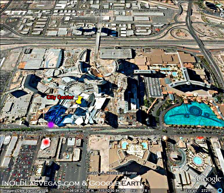
City Center Aerial & Satellite Views
1950 - 2008

July 1950
This aerial view shows the Los Angeles Highway and the Flamingo Hotel (which opened in 1946). The photos below show a 48 year progression of the Las Vegas Strip and traces the City Center property thru its various stages.
Notice the 'thumbtack icon' that is labeled 'City Center'. Progression photos, such as these, can be obtained by using Google Earth's new 'History' feature - which allows you to see the changes that have taken place in certain geographic locations over the years.

1965
Red-dot shows the Sands (opened in 1952), dark-purple-dot shows the future location for the (1989) Mirage, dark-blue-dot shows the location of (the later 1966) Caesars Palace Hotel, the light-purple-dot across the road shows the (1946) Flamingo.
The light-blue-dot show the (1955) Dunes Hotel (where the Bellagio is now). The light-green-dot show the site of the (1973) MGM Grand (now Ballys). The dark-green-dot shows the (1999) location of the Paris Hotel. The yellow dot shows the (1962) location of the Tally-Ho (later to become the 1964 King's Crown and then the 1966 Aladdin Casino and then the 2010 Planet Hollywood).
The light-orange-dot shows the Tropicana Golf Course across the street from the Tropicana Hotel. The golf course later became the site of the current MGM Grand (which opened in 1993). Across the street - the orange-dot showsthe location of the (1957) Tropicana Hotel.
City Center's site was vacant at this point, but the Dunes Hotel's Golf Course can be seen alongside the construction of the I-15 Freeway. The (2009) Vdara Hotel sits on the former site of the Dunes' Golf Course.

Small stores can be seen across the street from the 'thumbtack icon' that shows City Center's future location. The original (1973) MGM Grand had been built at this point. The (circa 1972) Jockey Club is seen across the street (below the Dunes).
The Maxim Hotel opened (in 1977) across the road (behind the Flamingo) from the original MGM Grand. The following year the small motel ( below the Flamingo) called the Desert Villa was replaced with the construction of the (1978) Barbary Coast.
The Marina Hotel opened, on the corner of The Strip and Tropicana Road, in 1975 across from the Tropicana Hotel. The Marina is now the west-wing of the (1993) MGM Grand.
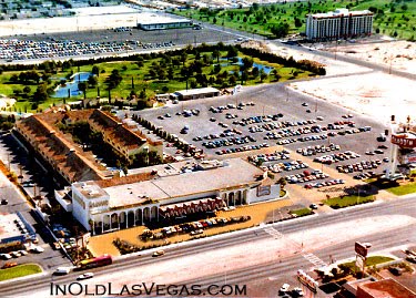
The Holiday Queen Motel opened in 1969 at the current site of City Center. In 1993 it became the Boardwalk Holiday Inn Hotel. The Boardwalk was imploded in May of 2006 to make way for City Center.

*Note: Notice Google's easy-to-use 'History Line' feature in top-left.
August 2004
This 2004 satellite photo shows the former location of the Boardwalk Casino-Hotel. The Boardwalk can be seen where the purple-dot has been placed. A good reference point for locating the Boardwalk, in photos, is the 'tent-like' , white structure (see red-dot) of the Hawaiian Marketplace.

2008
This 2008 photo shows the (purple-dot) former location of the Boardwalk Hotel across the street from the (red-dot) Hawaiian Marketplace. The Boardwalk was basically located where the entrance driveway to City Center is now located (and possibly occupied a slight bit of the Mandarin location). The Boardwalk extended northward into the area that is now Crystals' Mall.
2008 - Looking Westward
This additional photo is used to show more of the former Boardwalk's location. This satellite photo was taken in January and the result is that the winter-sunlight casts high-contrasting shadows which make it hard to distinguish certain things.
This view is the same location as seen above, but the camera was turned for a better glimpse. I lightened the shadow cast by the Mandarin Hotel to get a better glimpse of the driveway.
The purple dot shows where the Boardwalk was located (as referenced by the red-dot location of the Hawaiian Marketplace).
CITY CENTER - NOW & THEN

THEN
The Boardwalk Hotel-Casino formerly occupied the spot where City Center's driveway is now located. The Boardwalk (possibly) extended from near the Mandarin Hotel - across the driveway and into Crystals current location. I'm not 100% certain. I could be off by 50 yards or so.

NOW
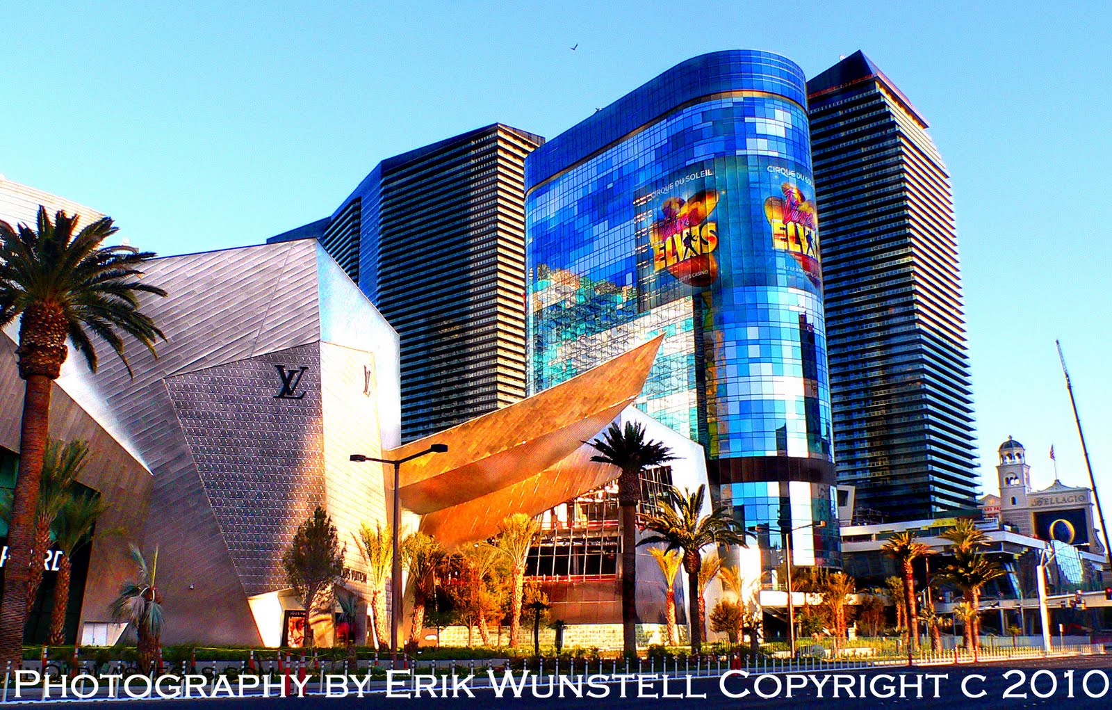
This April 2010 view shows the Mandarin Oriental Hotel (left), the City Center driveway and a portion of Crystals' Mall. The Boardwalk formerly occupied this area until 2006.

NOW
Another 2010 photo (about 200 yards north of the camera location seen above). The Boardwalk possibly extended into the space to the right of the Louis Vutton store. You can view the satellite photos to reach your own conclusion.

NOW
April night-view of City Center's driveway, the Mandarin, Veer Towers, Aria and Crystals. The former Boardwalk occupied the area just beyond the George Wallace billboard.

THEN
This 1975 aerial photo shows the Las Vegas lower Mid-Strip. The Tropicana Hotel is seen at bottom right, before they added their hotel tower, the following year. The Jockey Club can be seen at top-left and Aladdin-Planet Hollywood at mid-top (as marked).
COSMOPOLITAN & HARMON

THEN
This circa 1974 photo (judging by the gas price of 47 cents a gallon) is looking north-easterly from a location that might currently be seen if looking out from one of the Veer Towers.
The Dunes and (1973) MGM can be seen, along with the former site of Little Caesars and Churchill Downs Sports & Race Book in the mini-shopping mall (currently the site of the Paris Hotel). The edge of the Aladdin can be seen at the mid-right of this photo.
I am not too sure where the Harmon and Cosmopolitan Hotels line up exactly. They currently are across the street from the southern end of Planet Hollywood's property. This is roughly the spot where they are located (and these are the closest photos available, of the location,to show). The hotels might actually be about exactly where the camera position was for this photo.

THEN
This photo shows the former Texaco and Oasis gas station just south of the (1980) Dunes tower addition (seen behind these remains of the gas station's car-port and behind Denny's Coffee Shop). The Cosmopolitan and Harmon Hotels are currently located just south of this former gas station spot.
By the way. That former Denny's was an excellent spot to see celebrities after 2am. And yes. That $1.15 price for gas would place the date of this photo at around 1980 according to the Dept. of Energy's website.
NOW
Current view of Crystals, the Harmon Hotel and Cosmopolitan.

THEN
This 1966 photo shows the new I-15 freeway, the Dunes' Golf Course, Caesars Palace (yellow-dot), Flamingo (purple-dot), Dunes (dark-green-dot), vacant lot for the future 1967 Bonanza Casino and 1973 original MGM (light-green dot), the future Paris Hotel property (orange-dot), the Aladdin (pink-dot) and the northern edge of the current City Center's Cosmopolitan and Harmon (red-dot).
VDARA

THEN
This pre-1980 view is from the Dunes Golf Course (looking north-easterly towards Caesars, the Jockey Club Towers and the Dunes).

NOW
The (2009) Vdara Hotel is located almost exactly on the spot of the Dunes' Golf Course (seen above). The camera angle is looking north towards the Bellagio (former Dunes).
ALADDIN

THEN
View of the 1966 Aladdin after it bought the non-gaming (1962) Tally Ho property.
THEN
View looking east at the Aladdin Casino with its former Tally Ho room wings. Harmon Avenue is seen at right, with the Carriage House at top-right. The Aladdin remained a low-rise property until it built its 27-floor tower in 1975.

THEN
The (1975) tower at the Aladdin.

THEN
The Aladdin was imploded on April 27, 1998 to make room for the New Aladdin.

THEN
1999 view of the New Aladdin and Eiffel Tower under construction.

NOW
April 2010 view of the Planet Hollywood Hotel occupying the former New Aladdin Hotel.
PARIS HOTEL

THEN
A mid-eighties view of the current Paris Hotel property when it was a small shopping center. Little Caesars and the Chruchill Downs' Race and Sports book were formerly located in this mini-mall. This is where Bob Stupak placed and won his Million Dollar, Super-Bowl bet.

THEN
1966 view of The Strip (south of Flamingo Road). Caesars is nearing completion. The Three Coins Motel was located on the lot where the MGM/Ballys label is placed. The Galaxy Motel is seen at lower-right (just about where the north property line of the Paris Hotel is at now). Kerkorian's 1967 Bonanza Casino would open at the Galaxy motel, a year later.
The Dunes' Dome-of-the-Sea Restaurant and Denny's make good reference points for locating the Paris property in old photos.

THEN
1978 photo shows the original MGM Grand (red-dot). The yellow-dot shows the Barbary Coast under construction. The front of the Bonanza Casino can be seen added onto the former Galaxy Motel. Kerkorian sold the Bonanza Casino (blue-dot) around the time he opened the MGM.
Ballys current South Tower Addition (built in 1986) now occupies the area near the blue-dot. The green-dot shows the Churchill Downs Shopping Center. Paris Hotel now sits on the area of the green-dot.

NOW - 2008
The Paris Hotel's plaza fountain as seen two years ago, on the location of the former mini-mall.

NOW - April 2010
The Paris balloon and Arch of Triumph as seen from the top floor of the Bellagio's parking garage (located north of the Cosmop).

NOW - April 2010
View showing Ballys and Paris hotels
More 'Now and Then', Mid-Strip Photos Coming Next Week of:
the
* Original MGM Grand and Current Ballys
* Desert Villa Motel, Barbary Coast & Bill's Gambling Hall
* Caesars Palace Construction and Expansion


